Saturday, April 22, 2023

Horses in Pre-Columbian America


When I first heard the Book of Mormon criticized for the mention of horses, it didn't bother me, I knew that some day we would find proof that horses did indeed exist before the arrival of the Spaniards. Well that day has arrived. Read on.

Over the years, some LDS apologists would suggest things such as the Book of Mormon writers really meant deer. But I knew that if they were talking about deer, then Joseph Smith would have translated it as deer. Nowhere have deer been used as domesticated beasts of burden, so these apologists were just embarrassing themselves. The proverbial grasping at straws. That kind of "apology" only makes the criticism worse.

Others would suggest that maybe it was a tapir, a New World animal that Joseph Smith would not have known so he translated it as "horse." No. If Joseph didn't know the translation for an unknown animal he simply left it in the original language as he did with cureloms and cumoms.


Ether 9:19 And they also had horses, and asses, and there were elephants and cureloms and cumoms; all of which were useful unto man, and more especially the elephants and cureloms and cumoms.

Apparently, the belief that the American mustang was introduced by Spaniards was common knowledge at the time of Joseph Smith. So, why in the world would he include that in the book, "brilliant charlatan" that he was. Again, I knew that the book would be vindicated some day. Just like the criticism that the scientists at the time of publication in 1830 absolutly "knew" the book was false because it depicted high civilization and the scientists and scholars KNEW that the natives in America were nomadic savages and had nothing of the sort.

That criticism was short-lived because in 1841 Incidents of Travel in Central America, Chiapas and Yucatán by John Lloyd Stephens, with the incredibly detailed illustrations by Frederick Catherwood of the newly found "lost cities of the Maya." That book was joyfully welcomed and caught the fancy of the early Latter-day Saints - including Joseph Smith himself.

Likewise, the Lord will humble His critics of the mention of horses.

The sad thing is that the evidence of horses has been there all along. Over the years, if archaeologists found horse bones in their digs, they would simply toss them aside because they KNEW that horses were post-Conquest. They would indiscriminately dig through those layers in their quest for pre-Columbian strata. Think of all the evidence that has been destroyed.

In one instance, a certain cave had "tens of thousands of years of strata" inside it with habitation from modern man. But they found horse bones in every layer, including obvious non-Arab "native" horses. The archaeologist's explanation was that the native horses were the pre-historic horses that died out in the last ice age and that burrowing animals must have pushed those bones up into the more recent pre-Columbian strata. Anything, to avoid admitting they have been wrong all along.

That is my biggest frustration with modern science. They use unproven theories to "prove" new theories, so progress moves at a snail's pace and we are taken down wrong roads and spend years wandering around aimlessly until a new generation spends a lifetime overturning the previous egomaniacs' incorrect theories.

I take the majority of information for this post from the research reported by Daniel Johnson. His lecture and article on the subject should no longer remain obscure. The information is vital and fascinating.

The first recorded Spanish expeditions on the mainland continent of the Americas was 1519 when Cortes brought 13 or 16 horses with him when he set out to conquer Mexico.

Mr. Johnson argues that horses were central to some Native American tribes sooner than it would be possible if the only horses available were the horses that escaped from the Spaniards and bred in the wild, or even if they were stolen by natives and bred.

Plus the horses favored by the natives did not look like the horses the Spaniards had brought. The Spaniards favored solid color Arabian stallions, but the natives had large herds of smaller horses and favored the pinto, a multi-colored "painted" pony.

His sources, French and Spanish chroniclers of the 16th century, place the widespread use of horses long before the accepted dates of the spread of horses, above.

Dates of the first recorded mention of horses with the various tribes.
Mr. Johnson also points out that the Spaniards kept meticulous records of the horses they brought and can account for most of these horses. 

The expeditions did not bring mares because it caused trouble among the stallions. The Caribbean islands were used for breeding purposes. 


Besides these smaller, painted horses more closely resemble the "pre-historic" horses that were supposed to have died out during the last ice age. And all through the time mentioned above, the Arabian horses were breeding with the native horses to create the mustangs that we see today.


Sunday, June 30, 2019

A Day and a Half's Journey for a Nephite . . .

The Book of Mormon never says it is a day and a half's
journey from the East Sea to the West Sea.  Read it again.
The Book of Mormon is very consistent with it's language.

For example, "up" means up in elevation and "down" means down in elevation (never up north or down south).

"Northward" means "northeast or northwest" and "north" or "northern parts" means due north or nearly in the direction of cardinal north. "North" is not interchangeable with "northward."

It is very easy to inject our own language's idiosyncrasies into the Book of Mormon language. For this reason, one of the most misunderstood verses in the Book of Mormon is Alma 22:32 where it says:


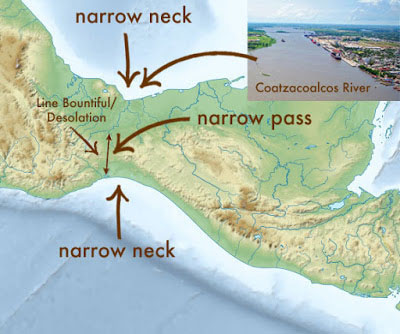
"And now, it was only the distance of a day and a half’s journey for a Nephite, on the line Bountiful and the land Desolation, from the east to the west sea; and thus the land of Nephi and the land of Zarahemla were nearly surrounded by water, there being a small neck of land between the land northward and the land southward."
Most people will paraphrase this as saying, "it takes a Nephite only a day and a half to journey from the EAST SEA to the WEST SEA." But read it again and you'll see that it doesn't say FROM THE EAST SEA.

It actually says "it was only the distance of a day and a half’s journey for a Nephite, on the line Bountiful and the land Desolation, from the east to the west sea" - or in other words - it was a journey of a day and a half from EASTERN END OF THE LINE that separates Bountiful and Desolation, passing through the narrow pass TO THE WEST SEA. Simply put it was a day and a half walk from one end of that boundary line to the other end, which ended at the west sea.

This fact is further clarified in Hellman 4:7 where it says:

And there they did fortify against the Lamanites, from the west sea, even unto the east; it being a day's journey for a Nephite, on the line which they had fortified and stationed their armies to defend their north country.

Note again, it does NOT say "east sea." The Book of Mormon language is precise. If Mormon meant to say "east sea" he would have said "east sea." Instead, he says that it is a day and a half journey from one end of the line to the other. From the west sea to the easternmost terminus of that defensive boundary line. The rest of the isthmus was impassable due to the the Coatzacoalcos River, a river that is navigable for large ocean-going vessels for almost 2/3rds of its length. That is almost halfway through the Isthmus of Tehuantepec. This is easily the reason for it being described as "the place where the sea divides the land." Ether 10:20

Too many Book of Mormon Geography models have run way off course because of the simple assumption that you have to find a REALLY narrow neck of land, from sea to sea, to make this verse fit.

This belief has been prevalent for so long that, unfortunately, the Spanish version of the Book of Mormon has been incorrectly translated to say, "from the sea of the east to that one of the west" OR "desde el mar del este al del oeste." See for yourself:

"Entire Hemisphere" Model
Alma 22:32 Pues bien, la distancia no era sino de día y medio de viaje para un nefita, por la línea de Abundancia y la tierra de Desolación, desde el mar del este al del oeste; y así la tierra de Nefi y la tierra de Zarahemla casi se hallaban rodeadas de agua, y había una pequeña lengua de tierra entre la tierra hacia el norte y la tierra hacia el sur.
Instead, it should be translated literally, like this: "...era solo la distancia de un día y medio de viaje para un nefita, en la línea de Abundancia y la tierra de Desolación, desde el este al mar oeste..."
"Andes Sunken Continent" Model

Curiously, however, the supporting verse in Helaman 4:7 is translated correctly:
Y allí se fortificaron contra los lamanitas desde el mar del oeste hasta el este; y esta línea que habían fortificado, y en la cual habían apostado sus tropas para defender su país del norte, era una jornada de un día para un nefita.
There is also confusion with the term "narrow pass" or "narrow passage." Many people assume it is another way to say "narrow neck." But that is not the case.

"American Heartland" Model
Remember, the language of the Book of Mormon is very consistent. Just like "north" and "northward" are not interchangeable, "narrow pass" is not the same as "narrow neck." It is indeed a narrow pass - exactly what Mormon called it.

This confusion is understandable because the "narrow pass" just happens to be in the "narrow neck." Mesoamerica has a narrow passage in the same place as a narrow neck. There is no other place in the Americas that fits BOTH requirements. And the distance that a Nephite can travel through the pass fits the Book of Mormon's description and the actual geography of the Isthmus of Tehuantepec.

"Isthmus of Rivas" Model
If you look at a map of the Isthmus of Tehuantepec, you will understand why Mormon included this explanation. It is because the easiest route from the land southward (greater Bountiful or Zarahemla) to the land northward (Desolation) was northwest along the western seashore of the land southward, then through a narrow pass that leads due north inland to the impassable boundary between the two lands (the Coatzacoalcos River), then turn northwest again and head into the land northward.

"What the Heck Let's Just
Make Anything Up" Model
In those days, there were no bridges across this river, making it practically impassable if you attempted to travel from the northern parts of the land Bountiful or Zarahemla directly into the land northward. You would have had to go up river until it was narrow enough to ford. And even that was a difficult journey because of the pantanos, or land of many waters. So the western route and narrow pass was the best way between the Land Southward and Land Northward.

"Baja California" Model
The remaining distance from the western end of "the line Bountiful and the land Desolation" to the "west sea" is exactly a day and a half on foot. The western end of the "line" is the eastern-most point of that day and a half journey - or in other words - "from the east [where that line ends, through the narrow pass] to the west sea."

Saturday, April 14, 2018

Line by Line Illustration of Alma 22

Using an actual map makes it easier to understand Mormon's
explanation of the geography of the promised land.
The most referenced passages in the Book or Mormon, when it comes to geography, are Alma 22:27-34. It is Mormon's most complete geography lesson.

It's an explanation of the geographical features that make up the borders between the lands of the Nephites and the lands of the Lamanites around 90 to 77 BC - the time of the sons of Mosiah - who left the land of Zarahemla and went up to the land of Nephi, in the Guatemala Highlands, to preach the gospel to the Lamanites.

I'll go through the verses one phrase at a time - line by line - and explain their meaning by illustrating on an actual map of the area where the Book of Mormon took place - southern Mexico and Guatemala.

...[Lamoni's father] sent a proclamation throughout all the land, amongst all his people who were in all his land, who
were in all the regions round 
about, which was bordering even to the sea, on the east and on the west...

One

Alma 22:27 "And it came to pass that the king sent a proclamation throughout all the land, amongst all his people who were in all his land, who were in all the regions round about, which was bordering even to the sea, on the east and on the west . . . "

King Lamoni's father ruled the greater land of Nephi from sea to sea, south of the dividing wilderness. It included the lands of Nephi, Middoni, Shilom, Shemlon, Lemuel and Shimnilom. It also included the land of Ishmael, which King Lamoni ruled.


...which was divided from the land of Zarahemla by a narrow strip of wildernesswhich ran from the sea east even to the sea westand round about on the borders of the seashore...

Two

". . . and which was divided from the land of Zarahemla by a narrow strip of wilderness, which ran from the sea east even to the sea west, and round about on the borders of the seashore. . ."

The "narrow strip of wilderness" is a mountain range. Read: The Narrow Strip of Wilderness Was Mountainous, but in a nutshell, the lands south of Zarahemla are consistently refered to as "up" from Zarahemla. So that means the river Sidon logically flows from those mountains - in a northerly direction.

It is the southern chain of mountains in the Guatemala highlands called the Sierra de las Minas and Sierra de Chuapus which run from the Caribbean Sea (sea east) and join up with the Sierra Madre on the Pacific (sea west). The Sierra Madre runs parallel to the shoreline, or in other words "round about on the borders of the seashore."

...the wilderness which was on the north by the land of Zarahemla, through the borders of Manti, by the head the river Sidonrunning from the east towards the west...

Three

". . . and the borders of the wilderness which was on the north by the land of Zarahemla, through the borders of Manti, by the head of the river Sidon, running from the east towards the west . . ."

Many readers think Mormon is restating or clarifying the "narrow strip of wilderness" here. But he is actually moving on. He's explaining there is more to the division between the Nephites and the Lamanites than the "narrow strip."

This division includes another layer of wilderness, another chain of mountains, that also runs east and west "on the north [side of the narrow strip] by the land of Zarahemla," along the borders of the land of Manti which is located in the headwaters (tributaries) of the river Sidon. This chain of mountains are the Sierra de Chama and the Sierra de los Chuchumalanes, which is divided by a pass that contains the headwaters of the Usumacinta River, a likely candidate for the River Sidon. 

There is also a spur of mountains that extends northward, into the land of Zarahemla. This was the area where the Gadianton robbers would later hide. "—and thus were the Lamanites and the Nephites divided."

Alma 22:27 mentions "east to west" three times and each time Mormon is describing three separate regions.

1) The land of Nephi runs "even to the sea, on the east and on the west."
2) The narrow strip of wilderness "runs from the east sea even to the west sea."
3) The borders of the wilderness that is "on the north by the land of Zarahemla, through the borders of Manti" that run "from the east towards the west."

After defining the wilderness areas that divided the Nephites from the Lamanites, he continues with an explanation of who lived where.


... idle part of the Lamanites lived in the wilderness, and dwelt in tents; and they were spread through the wilderness on the west, in the land of Nephi ... and also on the west of the land of Zarahemla, in the borders by the seashore, and on the west in the land of Nephiin the place of their fathers' first inheritance

Four

Alma 22:28 "Now, the more idle part of the Lamanites lived in the wilderness, and dwelt in tents; and they were spread through the wilderness on the west, in the land of Nephi; yea, and also on the west of the land of Zarahemla, in the borders by the seashore, and on the west in the land of Nephi, in the place of their fathers’ first inheritance, and thus bordering along by the seashore."

The Lamanites who built cities and ruled as kings over their subjects lived mostly south of the wilderness areas that separate the Nephite and Lamanite lands. However, there were nomadic Lamanites living in the wilderness north of the narrow strip but south of Nephite lands - sometimes referred to as the "south wilderness" - as well as spilling over into the coastal areas east and west of the land of Zarahemla.


... there were many Lamanites on the east by the seashore ... And thus the Nephites were nearly surrounded by the Lamanites ... the Nephites had taken possession of all the northern parts ... east to the westround about on the wilderness ... on the north 

Five

Alma 22:29 "And also there were many Lamanites on the east by the seashore, whither the Nephites had driven them. And thus the Nephites were nearly surrounded by the Lamanites; nevertheless the Nephites had taken possession of all the northern parts of the land bordering on the wilderness, at the head of the river Sidon, from the east to the west, round about on the wilderness side; on the north, even until they came to the land which they called Bountiful."

A spur of mountains (wilderness) separated the eastern and western portions of the greater land of Zarahemla. 

You'll find the cities of Ammonihah, Noah, Judea, Melek in the valley on the west of that mountain range and the cities of Zarahemla, Antionum, Jershon, Gideon and Manti on the east side. The city of Bountiful was later built on the north coast, near the narrow neck of land.

As Nephites traveled from east to west Zarahemla, they had to go "round about" this wilderness "on the north" side. The Book of Mormon sometimes says they would go "over" to the other lands, because they had to go up and over those mountains through mountain passes in the northernmost part of the range then down in to the valley where the cities were located.


... the land which they called Bountiful. And it bordered upon the land which they called Desolation, it being so far northward that it came into the land which had been peopled and been destroyed ...

Six

Alma 22:30 "And it bordered upon the land which they called Desolation, it being so far northward that it came into the land which had been peopled and been destroyed, of whose bones we have spoken, which was discovered by the people of Zarahemla, it being the place of their first landing."

The land Bountiful was situated along the north coast of the land southward. The dividing line between it and the land Desolation was the Coatzacoalcos River.

If you are wondering why the Yucatan peninsula is missing in the maps I use, read: Yucatan Island and the Land Bountiful.


[the land northward] was discovered by the people of Zarahemla, it being the place of their first landing (1). And they came from there up into the south wilderness (2). Thus the land on the northward was called Desolation, and the land on the southward was called Bountiful

Seven

Alma 22:31 "And they came from there up into the south wilderness. Thus the land on the northward was called Desolation, and the land on the southward was called Bountiful, it being the wilderness which is filled with all manner of wild animals of every kind, a part of which had come from the land northward for food."

The Book of Mormon's mention of the Mulekites "first landing" implies that there was at least one other landing later. Just like Lehi's family, the people of Zarahemla didn't settle where they first landed. But unlike Lehi's family, who "journeyed in the wilderness," the Mulekites continued on in their boats until they came to their final destination - downriver from where "they came from there up into the south wilderness" and founded the city of Zarahemla.

... the distance of a day and a half's journey for a Nephite, on the line Bountiful and the land Desolation, from the east to the west sea ...

Eight

Alma 22:32 And now, it was only the distance of a day and a half’s journey for a Nephite, on the line Bountiful and the land Desolation, from the east to the west sea . . .

The Book of Mormon is very consistent with its language. The oft recited "it takes a Nephite a day and a half to go from sea to sea" is a misquote. It does NOT say "east sea."


It says "on the line Bountiful and the land Desolation, from the east to the west sea. . .


The said distance of a day and a half's journey begins from the eastern end of the dividing line between Bountiful and Desolation, which ends at the west sea


That eastern end of the line between Bountiful and Desolation ends where the Coatzacoalcos River begins to be fordable. It is a river that is navigable for large ocean-going vessels for almost 2/3rds of its length. That is almost halfway through the Isthmus of Tehuantepec - easily the reason for it being described as "the place where the sea divides the land." Ether 10:20

... land of Nephi and the land of Zarahemla were nearly surrounded by waterthere being a small neck of land between the land northward and the land southward ...

Nine


". . . and thus the land of Nephi and the land of Zarahemla were nearly surrounded by water, there being a small neck of land between the land northward and the land southward."

Alma 22:33 "And it came to pass that the Nephites had inhabited the land Bountiful, even from the east unto the west sea, and thus the Nephites in their wisdom, with their guards and their armies, had hemmed in the Lamanites on the south, that thereby they should have no more possession on the north, that they might not overrun the land northward."

It was a constant battle to keep those Lamanites in their territories in the south. It was like Whac-a-Mole because if the Lamanites found resistance at one entrance they had plenty of ways to go "round about in the wilderness" and test the strength of another entrance.


... the Nephites had inhabited the land Bountiful, even from the east unto the west sea, and thus the Nephites in their wisdom, with their guards and their armies, had hemmed in the Lamanites on the south ...
The Nephites placed armies in the various mountain passes and along the seashore where people could enter into the lands of Zarahemla or Bountiful from either the land of Nephi or wilderness in between.

Alma 22:34 "Therefore the Lamanites could have no more possessions only in the land of Nephi, and the wilderness round about. Now this was wisdom in the Nephites—as the Lamanites were an enemy to them, they would not suffer their afflictions on every hand, and also that they might have a country whither they might flee, according to their desires."

They especially wanted to keep them from settling in the land northward or else they would be entirely sourrounded by their enemy with no avenue of escape. They needed to keep the entrance into the land northward free in case they ever had to escape the encroaching Lamanites. 

Friday, April 13, 2018

In the Footsteps of Limhi's Expedition

The route that Limhi's expedition took when they tried to find Zarahemla but found the Land of Desolation instead.*

Sierra de las Minas, Guatemala
I think I know why "the small number of men" that Limhi sent out in search of Zarahemla got lost. The Nephites wanted help from Zarahemla to escape bondage from the Lamanites but "the king of the Lamanites set guards round about the land, that he might keep the people of Limhi in the land, that they might not depart into the wilderness" (Mosiah 19:28). 

For this reason, they were unable to leave the normal way, which was to head through the pass in the narrow strip of wilderness, north of the Land of Nephi. So they decided to head south, away from the guards then turn west until they found the source of the River Sidon then follow that down to the City of Zarahemla. 
Chixoy River, Guatemala (AKA Rio Negro, or Rio Salinas)
However, when they reached the top of the mountain they saw two rivers. (See the dot in the above illustration.) One flowed north then turned due east, the direction from which they had just come. The other flowed northwest. 

They knew that Zarahemla was northward from Nephi so they picked the wrong river, followed it all the way to the mouth where there are plenty of lagoons - a "land of many waters" - and found the land where the Jaredites' final battle had occurred. They returned via the same route with the Jaredite records in their possession.
The "pantanos" of Vera Cruz and Tabasco is the land of many waters.
Mosiah 21: 25-27 Now king Limhi had sent, previous to the coming of Ammon, a small number of men to search for the land of Zarahemla; but they could not find it, and they were lost in the wilderness. 
Nevertheless, they did find a land which had been peopled; yea, a land which was covered with dry bones; yea, a land which had been peopled and which had been destroyed; and they, having supposed it to be the land of Zarahemla, returned to the land of Nephi, having arrived in the borders of the land not many days before the coming of Ammon. 
And they brought a record with them, even a record of the people whose bones they had found; and it was engraven on plates of ore.
Model of Kaminaljuyu
The majority of Mesoamerican/Book of Mormon scholars believe the city of Nephi was Kaminaljuyu (Guatemala City). But I'm not convinced. Mainly, because the city of Kaminaljuyu was a mature city, established almost a thousand years before the time when Nephi arrived with "all those who would go with [him]" after departing into the wilderness to flee from his brothers around 575 BC. (2 Nephi 5:5)
It makes no sense for a group of newcomers to waltz in to a big city and say, "We're here to rule over you and show you how to build a temple and make swords and stuff." Instead of Kaminaljuyu, they found a remote valley with either no inhabitants or people who welcomed them to their small community. 
Motagua River valley, El Progresso department, Guatemala
I believe that valley was the upper Motagua River valley. The city of Nephi was nestled in the valley south of the Sierra de las Minas, which along with the Sierra de Chuacus are "the narrow strip of wilderness, which ran from the sea east even to the sea west." Nephi's temple was built on a hill and the tower next to it gave them a commanding view of Shilom across the valley and Shemlon further downriver towards the east in the same river valley.
The city of Nephi was abandoned to the Lamanites when Mosiah and his people migrated to the land of Zarahemla around 200 BC. It was reclaimed again by Nephites when Zeniff and his people went back and struck a deal with the Lamanites so they could re-settle there in 121 BC. 
This is another reason why the city of Nephi can't be Kaminaljuyu. When Zeniff arrived, the Lamanite king "commanded that his people should depart out of the land, and [Zeniff] and [his] people went into the land" to possess it. I can't imagine any Lamanite king commanding thousands, possibly tens of thousands, of inhabitants in Kaminaljuyu to leave in order that a handful of Nephites could settle there.
On the way to the mountain top via a tributary of the Motagua River
Recap: During Limhi's time, his expedition headed south, then west, up the Motagua River until they reached the ridge overlooking the Grijalva and Chixoy watersheds. (See the spot in the above illustration.) The Chixoy flows north then due east before it loops around and heads north to become the Usumacinta (River Sidon). The Chixoy appeared to be the wrong river because it headed the wrong direction from their vantage point. The Grijalva looked more promising so they followed it - the wrong river.

Sources:
* My map above uses the position of the Grijalva as it was 2000 years ago. Read: Wandering River by Kirk Magleby

Thursday, April 12, 2018

In Search of the Waters of Mormon

Semuc Champey, Guatemala, which is Mayan for "sacred waters"
is a possible candidate for the Waters of Mormon.
The Book of Mormon is larger than life because of the huge impact on our lives. As we come closer to finding out where the book took place, we tend to make the mistake of looking for huge things.

One example is the temptation to think that Kaminaljuyu (Guatemala City) is the city of Nephi and Lake Atitlan is the Waters of Mormon. I mean, they ARE the first thing to jump out at you when you look at a map of the land south of the "narrow strip of wilderness," right?

That's not much better than the same mistake we made growing up, when we thought that the Land Southward was South America, the narrow neck was Panama, and the Land Northward was North America. Way too big. Even then, that subconsciously didn't feel right.

Las Conchas, Alta Verapaz, Guatemala
It seemed obvious at first, but after a careful read you realize their travels where measured in days and weeks, not months and years, which would be the case if the entire Western Hemisphere was the setting for the Book of Mormon.

A careful reading about Limhi's expedition should have made it clear right away that the setting had to be a very limited geographical area.

Focusing on Kaminaljuyu and Atitlan isn't much better though. Yes, it's much smaller than the entire hemisphere but still too big. Read about my simple reasons why Kaminaljuyu can't be the city of Nephi: In the Footsteps of Limhi's Expedition.

Guatemala and southern Mexico are filled with possible candidates for the Waters of Mormon without having to zero in on the largest lake on the map.

One of the many pools at Semuc Champey, Alta Verapaz, Guatemala
The images on this page are just a few of the many stunning possibilities for the Waters of Mormon. You would just have to find one like these within a couple days' journey from any proposed site for the city of Nephi.

One of the most beatiful ones is called Semuc Champey, a series of cascades and deep clear pools, whose name means "Sacred Waters" in the local Mayan language, Kekchi.

Mosiah 18:4-5,30. . . as many as did believe him did go forth to a place which was called Mormon . . . being in the borders of the land having been infested, by times or at seasons, by wild beasts.
Balneario Pasabien, Zacapa, Guatemala
Now, there was in Mormon a fountain of pure water, and Alma resorted thither, there being near the water a thicket of small trees, where he did hide himself in the daytime from the searches of the king. 
And now it came to pass that all this was done in Mormon, yea, by the waters of Mormon, in the forest that was near the waters of Mormon. . .

Water features like Semuc Champey have the added benefit that they are in secluded areas, thus a natural place to hide. The narrative in the the above passages doesn't lend itself to a huge lake in the Guatemalan altiplano, like Atitlan, with wide open spaces and sparse vegetation around the beaches. Besides, since when was a lake ever considered a "fountain of pure water?"

Cascada del Río Sachichaj, Alta Verapaz, Guatemala
The forest of Mormon, in the borders of a land infested by wild beasts, sounds more like the lush growth in the departments such as Alta Verapaz, Baja Verapaz, Zacapa, El Progress, Peten or Chiapas.

Mosiah 18:31-34 And these things were done in the borders of the land, that they might not come to the knowledge of the king. 
But behold, it came to pass that the king, having discovered a movement among the people, sent his servants to watch them. Therefore on the day that they were assembling themselves together to hear the word of the Lord they were discovered unto the king. 
And now the king said that Alma was stirring up the people to rebellion against him; therefore he sent his army to destroy them. 
And it came to pass that Alma and the people of the Lord were apprised of the coming of the king’s army; therefore they took their tents and their families and departed into the wilderness.

The Waters of Mormon were close enough to the city of Nephi to enable repeated and constant contact, but far enough away that they needed to take tents.

NOTE: Any of these could also be candidates for the Land of Helam, which the Book of Mormon describes in Mosiah 24:3-4 in this way: "And they fled eight days’ journey into the wilderness.
4 And they came to a land, yea, even a very beautiful and pleasant land, a land of pure water."

Semuc Champey just happens to be found in the South Wilderness and is roughly 8 days journey from the most likely candidate of the land of Nephi, both of which match the text. So, I feel that Semuc Champey is more likely to be in the land of Helam, rather than the waters of Mormon.

Mosiah 24: 3-4 And they fled eight days’ journey into the wilderness. And they came to a land, yea, even a very beautiful and pleasant land, a land of pure water.

Semuc Champey, Alta Verapaz, Guatemala
Agua Azul, Chiapas, Mexico
I focus a lot on Semuc Champey because of its name and beauty. I'm not saying it is absolutely the Waters of Mormon, especially since they are pretty remote and not close enough to any of the current proposed sites for the city of Nephi. It does, however, fit the narrative of possibly being the Land of Helam.

These photos are for illustrative purposes so you can envision what was most likely meant by the Waters of Mormon.  There are many water features like this throughout the country of Guatemala or the state of Chiapas, Mexico.

Cascadas Las Nubes, Chiapas, Mexico


Sources:
SWIMMING IN SACRED WATER: SEMUC CHAMPEY OF GUATEMALA

Monday, April 9, 2018

Which One is the Narrow Strip of Wilderness?

The Sierra de las Minas/Chuacus range is the straightest, narrowest,
most continuous, east-west candidate for the narrow strip of wilderness.
Most Book of Mormon scholars recognize that the "narrow strip of wilderness" is a mountain range. Read: The Narrow Strip of Wilderness Was Mountainous. Further, most Mesoamerican/Book of Mormon scholars argue that the mountains in central Guatemala are those very mountains.

The problem with that is they are so vast and wide that it makes the distances too great to fit the narratives in the Book of Mormon that mention the duration of their travels. It also negates the entire concept of a "narrow strip."

The solution is to look more closely. When you do, you see that there are basically two strips - one more narrow than the other.

Heading south from Peten, you pass through two distinct east-west mountain chains, then you reach the Sierra Madre along the coast that spreads out to form the southern Guatemalan Highlands where Guatemala City is located. Read: In the Footsteps of Limhi's Expedition, for the reasons why Kaminaljuyu (Guatemala City) could not possibly be the city of Nephi.

The "narrow strip of wilderness" consists of the Sierra de las Minas and the Sierra de Chuacus that run in a straight line from the Caribbean Sea until they meet up with the Sierra Madre, which runs parallel to the Pacific coast. This fits the description in Alma 22:27 which says the narrow strip runs "from the sea east even to the sea west, and round about on the borders of the seashore

Chixoy River, Guatemala
This would make the upper Motagua River valley in the department of El Progresso the land of Nephi since it is immediately south of the range. There is a high mountain pass, between the Chuacus and de las Minas - the only reasonable way through this rugged, tall and very narrow strip of mountains.

Then there is another (not so narrow) strip of wilderness in the form of the Sierra de Santa Cruz, Chama, and Cuchumatanes. These run east-west as well, are north of the "narrow strip" and borders on the land of Zarahemla by passing by the borders of Manti where the tributaries (or head) of the river Sidon are. So the next phrase in Alma 22:27 is not a repetition of the description of the "narrow strip" but an explanation of the next layer of wilderness. Read the next phrase, look at the map, and see if you have an "aha" moment like I did.

". . . and the borders of the wilderness which was on the north [of the narrow strip] by the land of Zarahemla, through the borders of Manti, by the head of the river Sidon, running from the east towards the west—and thus were the Lamanites and the Nephites divided."

Manti would be in the hills of northern Alta Verapaz because Manti was near the headwaters of Sidon (The Book of Mormon definition of headwaters is the tributaries of the river Usumacinta, or Sidon). Manti is part of the greater land of Zarahemla and lies in between the lesser land of Zarahemla and the land of Nephi - higher up in elevation.

So, Alma 22:27 mentions "east to west" three times and each time it is describing three separate regions.

1) The land of Nephi runs "even to the sea, on the east and on the west."
2) The narrow strip of wilderness "runs from the east sea even to the west sea."
3) The borders of the wilderness that is "on the north by the land of Zarahemla, through the borders of Manti" that run "from the east towards the west." (Sometimes called the "south wilderness.")

". . . and thus were the Lamanites and the Nephites divided"


Alma 22:27 And it came to pass that the king sent a proclamation throughout all the land, amongst all his people who were in all his land, who were in all the regions round about, which was bordering even to the sea, on the east and on the west, and which was divided from the land of Zarahemla by a narrow strip of wilderness, which ran from the sea east even to the sea west, and round about on the borders of the seashore, and the borders of the wilderness which was on the north by the land of Zarahemla, through the borders of Manti, by the head of the river Sidon, running from the east towards the west—and thus were the Lamanites and the Nephites divided.

Semuc Champey (Sacred Waters), Guatemala
Alternative: Dr. Richard F. Hauck believes the city of Nephi is in the valley of Salama in the department of Baja Verapaz. That would mean the northern, and less narrow, mountain chain that starts on the east coast with the Sierra de Santa Cruz, then the Sierra de Chama, followed by the Sierra de los Cuchumatanes and finally the Sierra Madre on the Pacific Coast would be the narrow strip. If this turns out to be the case, then Semuc Champey could be a candidate for the waters of Mormon because it is close enough to fit the narrative in the Book of Mormon.

But alas, I don't think it is because I see a few problems with the Santa Cruz/Chama/Cuchumatanes "narrow strip."

1) They are not as tall as the Chuacus/de las Minas chain (until you get to the Cuchumatanes).

2) They don't run as true east-west as Chuacus/de las Minas (Sierra de Chama actually bends southwest and almost meets up with Chuacus.

3) There is a large river valley, lowland gap between Sierra de Chama and the Cuchumatanes and a river valley gap between Santa Cruz and Chama. So they don't technically run from the "sea east even to the sea west."

4) The Cuchumatanes is not in the least bit narrow, they are very spread out and have many large mountain valleys.

5) There is no additional "wilderness which was on the north by the land of Zarahemla, through the borders of Manti, by the head of the river Sidon, running from the east towards the west" in between this narrow strip and the Nephite lands, because the Santa Cruz/Chama/Cuchumatanes mountains and valleys ARE that very wilderness, sometimes called the "south wilderness," where "the more idle part of the Lamanites lived."

Sources:
Sierra Madre
Sierra de los Cuchumatanes
Sierra de Chama
Sierra de Santa Cruz
Sierra de Chuacus
Sierra de las Minas